THE MINI guide… North Finistere, France
Paddling in North Finistere
Words & photos: Helen Trehoret
SUP Micro Adventures is one of the best parts of SUP. With the usual time constraints that we all face, it takes work to plan and execute a 10-day SUP expedition. This is why living and paddling in North Finistere is so unique; we can zip off for a quick micro-adventure at just a moment’s notice. The wind direction and tides are all we need to know. Grab a SUP board, tent, and sleeping bag, and we are ready. Moreover, you can choose your comfort level for these micro-adventures between extremely comfortable, comfortable, and bivouacking.
https://maps.app.goo.gl/2ukeyTYaFRTerN9Z7

Everybody has some link to France, but do you know Finistere, and how perfect is it for SUP Adventures? Let me guide you through the perfect adventure in North Finistere, which is adapted to three different comfort levels! This is the armchair guide to the perfect micro adventure in North Finistere.
North Finistere, or as the locals call it, ‘The Forgotten Coast’. In an area of France that you have not heard about, there are no expensive ad campaigns, nor is it anything to do with the clothing brand. As the name suggests, North Finistere is at the end of the world. Untouched by the mass development that is dominant in the south, you can still find yourself alone on the sea, with only seals and kelp forests for company. They say it is like Cornwall 50 years ago.
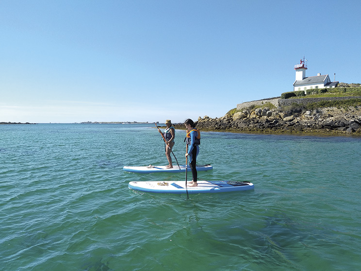
Let’s zoom onto Lilia, Plouguerneau, and Pays des Abers. It is 40 km west of Roscoff and 20km north of Brest. Abers is the Breton word for river mouth, a name shared with its Welsh cousins. This is a land of a 1000 islands, with the island archipelago strutting out, protecting the land from the fiercest of storms. The islands vary in size, from being big enough to set up a military seaplane base to being only fit for basking seals and nesting birds.
Journey 1: The charge of the lighthouse keeper!
I take this journey with friends and family, and I want a bit more comfort!
This journey starts at Lilia, the small seaside village. You glide out of the Bay de Kervenni on the high to mid tide to benefit from the ebb tide while having enough depth to glide effortlessly over the sea grass and seaweed in the bay before turning northeast to start tracking around the rocks and micro-islands where curious seals will often follow you. Following the ebbing tide, you can let yourself be taken effortlessly by the current, using your SUP paddle to guide your SUP board around hidden rocks and floating seaweed waiting to snag your fin. After only 2 km, you are rewarded with an arrival at Ile Vierge, Europe’s tallest stone lighthouse!
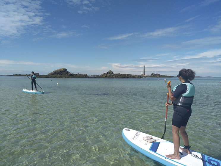
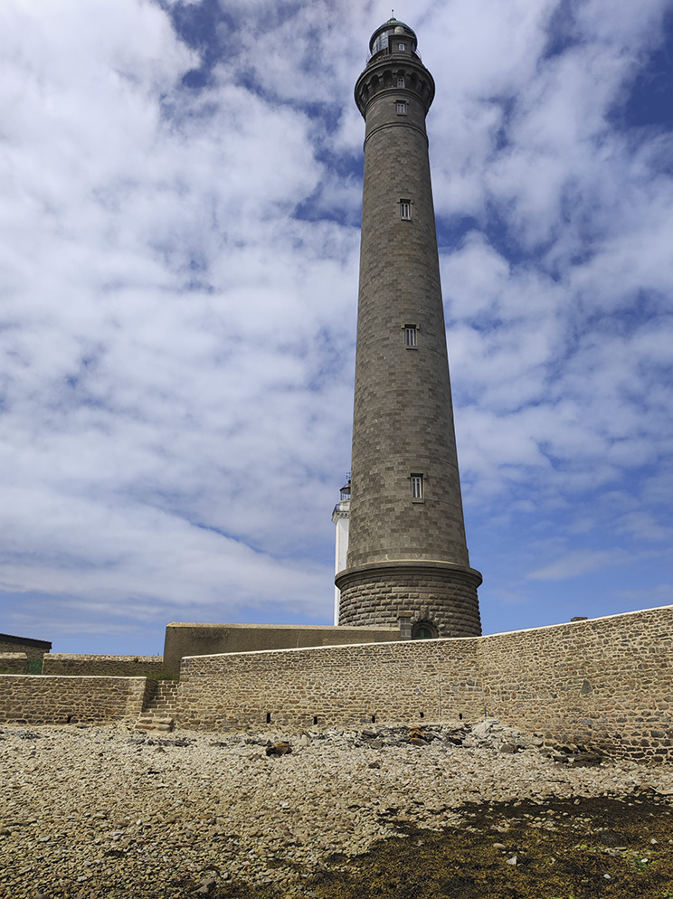
This island is the site of an active lighthouse, though, like most these days, it is fully automated. However, this island’s gem is the gite found behind the lighthouse. If you are a person who enjoys comfort, you can stay in the gite for the night (or two) and immerse yourself in living the life of a keeper. The accommodation is tastefully decorated to keep its identity, including traditional wooden closed beds. Moreover, the gite includes the ancient lighthouse, so you can watch the sunset after climbing all 250 steps! Make sure you don’t forget the corkscrew!
The outward journey ends with descending into the small dock area constructed for the lighthouse keepers. Turning west, you begin to navigate through an abundance of rocky islands before heading towards Stagadon. The other island has accommodation in the Archipelago. This is an area where you will need sharp eyes to spot the access points and practice your turns and SUP control.
Journey 2: Stagadon:
The charge of the sheep!
After leaving Ile Vierge, you will be taken through narrow channels while gliding over pristine sea grass and kelp areas. All around you will be nesting birds and the shrill of birds calling each other. The locals (the local seals) will almost guide you if you get the tide right as you approach Stagadon; the sea floor changes from rocky to sand. At this point, the sea colour changes to a brilliant blue and green, and you would think you have landed in the Caribbean.
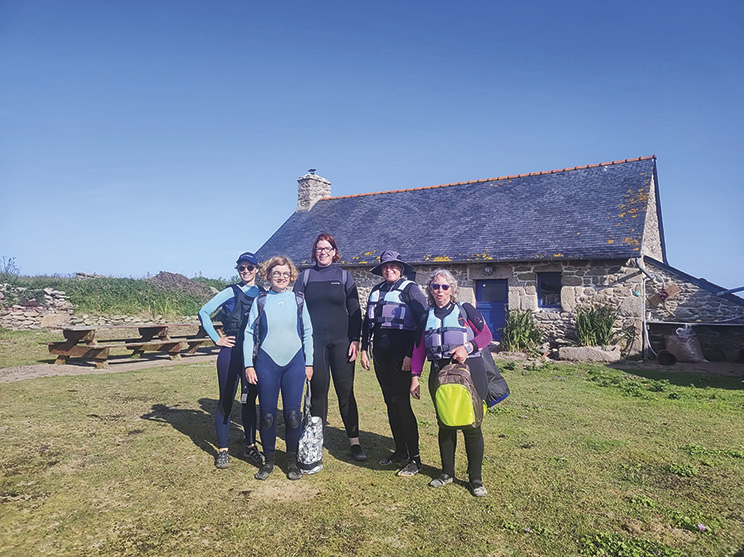
The beach lies in the lee of the island, protecting you from the dominant westerly winds. The local Seventh-day evangelist owns the island. It is a cosy place to spend the night in relative comfort. The island has a minimum water supply collected from rainwater, and electricity is generated on the island. It is the ultimate eco-lodge!
If your pockets are not deep enough to stretch to a night in the light housekeeper’s gite, then Stagadon is the island for you. On Stagadon, the famous Ouessant sheep were once farmed. The sheep are as temperamental as the winds that flow over these lands in the winter. But for now, the old farmhouse functions as a bothy for up to 25 people (plus a few sheep to help control the Machair).
Exploring the Stagadon is a step back into island life. After a short walk, you can get comfortable in the bothy and even light the BBQ while enjoying the sunset.
Once you have spent the night on the island, you break camp in the morning to paddle due south to skirt by Ile Wrac’h – a second island with a smaller lighthouse.
The abundance of lighthouses tells us that this is where you need to ensure your tides are right. A spring tide in this area completely changes the landscape, making it a current nightmare or, at low tide, a rocky, strewn, unnavigable landscape.
Journey 3: Ile Wrac’h
This is for the tough and cultured outdoorists! After completing the bay circuit, passing by Ile de Vierge and Stagadon, this option is to arrive on Ile Wrac’h at sunset and bivouac on the island. This is a protected area, so camping is not permitted, although small-scale bivouacking is tolerated.
This is a historically interesting island. The area adjacent to the island was once a US seaplane base in World War I. The approach to the beach is lined with rocks, so it’s all about nailing that tide. After spending the night in the comfort of the Machair, heading off at high tide allows you to circumnavigate the island and glide over the oyster beds that litter this side of the Archipelago.

Still, on high tide, you can squeeze between the islands, allowing you to complete the loop of the Archipelago! Afterwards, you can reward yourself with a glass of wine and a dozen fresh oysters!
How to get to North Finistere. The nearest ferry is Roscoff, 30 km west of Pays des Abers. Turn right, and you will start your journey to Cornwall from 40 years ago!
When is the best time to paddle? Any time from Easter to October. But get in tune with your tides and wind predictions to truly nail this circuit!
Are you eager to try this loop? Visit www.barrachousup.com for your guide.

Leave a comment